
My ultimate summer destination is the Hautes-Alpes. It's a mixture of different ingredients that ultimately makes the perfect recipe. Let's go through them and you will see that in the end you will be convinced:

- Accessibility: with the highway to the gates of Gap, access by car is quite quick. Then until Briançon, the Nationale is comfortable. The only downside is the road traffic which is heavy during the summer months.
- The weather: located in the Southern Alps, this area benefits from exceptional sunshine. In the north of the department, the Col du Lautaret is the blocking point for depressions coming from Isère. When it is cold and humid in the north on the other side of the pass, in Briançon, it can be sunny.
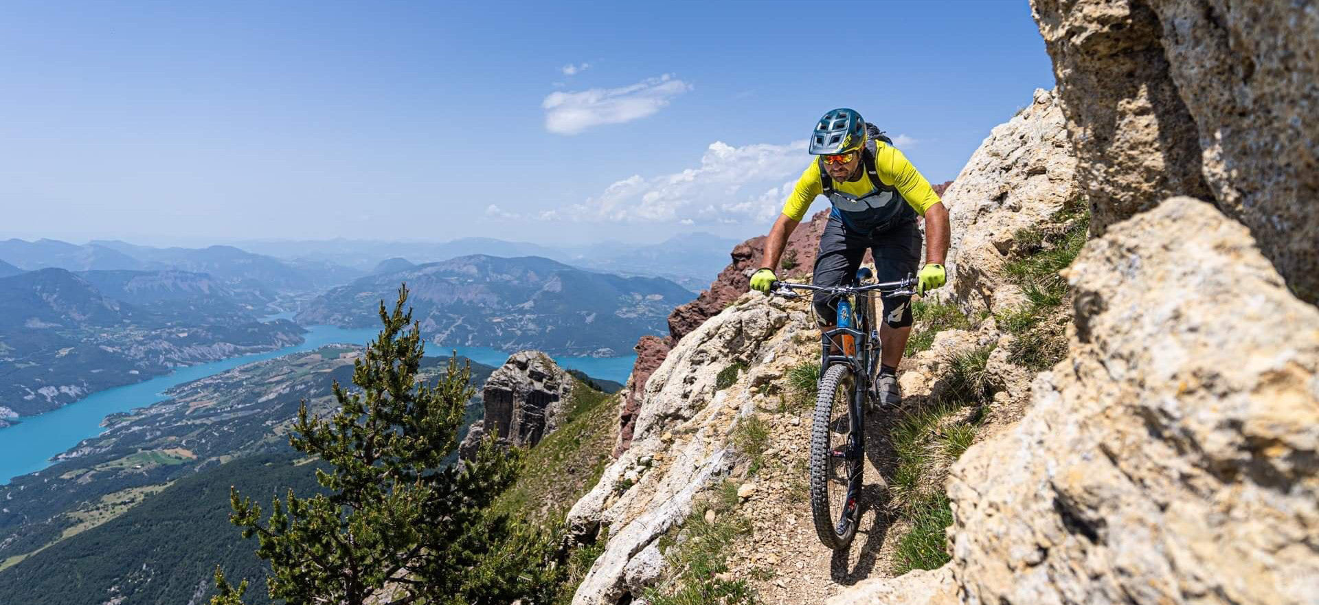
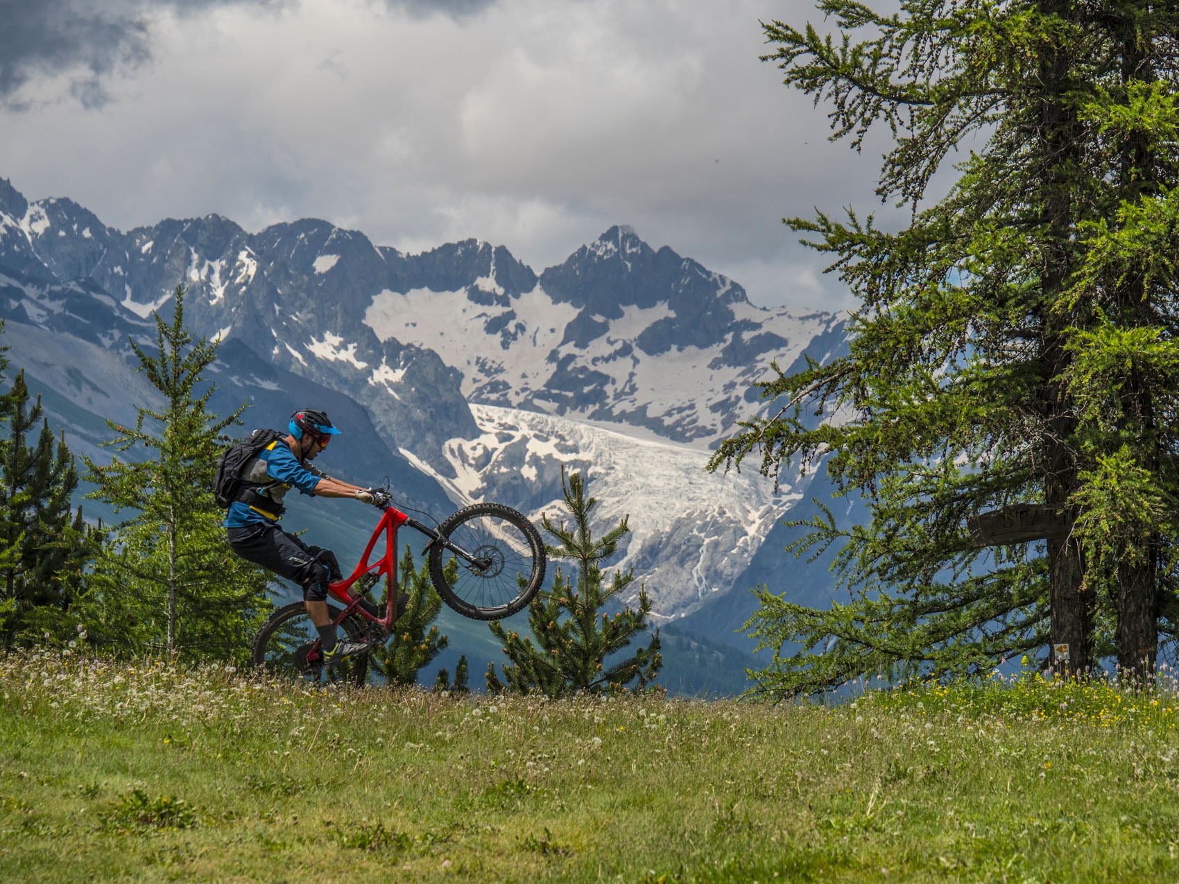
- The landscapes: glaciers and sharp peaks are not the prerogative of the northern Alps. Here the landscapes of the Ecrins massif are simply fantastic with 2 peaks exceeding 4000 m altitude! Concerning mid-altitude landscapes such as mountain pastures, take a trip to Queyras and let us know what you're up to!
- The trails: as they say in the jargon, this is the heart of the mill! The marked trail network is excellent and the possible mountain bike routes are legion. Little chance of riding a quality prayer route, the playing field is XXL. Be careful, mountain biking in the Ecrins National Park is prohibited, but whatever happens the best trails for biking are not there.

We have planned a beautiful day in the mountains this Sunday near the Val d'Allos. However, due to disturbances coming from the south and east, the weather forecast is not very favorable for this sector. Heavy storms are expected, it would be dangerous to venture on remote and high altitude routes in such conditions. I start to think of 1000 plans, my brain is smoking. Friends have blocked their day, might as well try to do something. Because throughout the year, whether it is Narbaix, Nico or myself, we are very often at the origin of wrinkles. And that requires a lot of time and knowledge of the sectors. The famous TV saying “I love it when a plan goes off without a hitch” is kind of my adage. I leave little room to chance, in any case, the hazards being already numerous (equipment breakage, fall, etc.), I might as well minimize the part of chance in the rest of the day. I scan the weather maps carefully and I see that the Hautes-Alpes seem to be spared by precipitation. Everything around is catastrophic: Isère, Savoie, Alpes-Maritimes and Alpes de Haute-Provence, the weather is too uncertain. And again, looking more closely, the south of the Hautes-Alpes would be reached quite early by the storms and Queyras under Italian weather influence would have the same program. There remains a targeted area between Embrun and Briançon, along the Durance. It seems limited but the possibilities are numerous and the quality of the routes is extraordinary.

The day before, a quick look at the weather forecast shows that storms could rage from 3:00 p.m. I decide to bring forward the departure very early in the morning, a few defections appear. Finally, there are 7 of us leaving: Narbaix, Nico, Fred, Romain, Arnaud, Jenssy and myself. As an itinerary, I am planning a short crossing of the Ecrins, from Puy-Saint-Vincent to Roche de Rame. It seems quite close, but when you choose your route carefully, it starts to get steeper. Knowing that there are electric vehicles with us, we have to manage autonomy and avoid portages. We leave the vehicles on the heights of Puy-Saint-Vincent, the sky is clear, clear of all clouds. It smells like a good day. Even though we know that the weather can turn quickly in the mountains, whatever happens we have several hours ahead of us before things get bad.

When you ride with several people, there is always a little inertia. From the start, I feel Romain tired, he closes the group and doesn't seem to find his rhythm. We have traveled together several times (Peru, USA, etc.) and I know he is resourceful. But there, the change of job and the arrival of his daughter must not have helped him maintain his condition. I already know that we will have to change the program for the day. Once we arrive at the heights of the Puy Saint-Vincent ski area, we follow a trail in the woods which, in season, is shaped by the resort. For now, it is cluttered with branches, we feel that winter has come late in the Alps. Once on the ridge, whereas before the path reached a beautiful mountain pasture, it is now a really wide ski slope and an artificial lake (for the snow cannons we presume) which sets the scene. We are really disappointed with these developments which, let us say, have disfigured such a beautiful place.

We trace through the mountain pastures, facing south, the path is invisible at the start. Then after a good hundred meters of difference in altitude, we spot the base of the path which becomes wider and clearer. When we enter the woods, the trail is really playful and fast, a real joy. The path leads to a new mountain pasture in the middle of the magnificent Clausas chalets. We take a little break, the place is so beautiful, the view of the Fournel valley is magical. It's always a special moment to be with your friends in such a place. From there, we go up the track to the Col de la Pousterle, then to Les Têtes. Switching to the Durance side, the view of the valley is impressive. We feel that the descent is going to be steep. The trail is never extreme. At the beginning, it travels on this wide wooded ridge then when it descends directly into the Bois de la Pignée, you have to manage the very tight hairpins, the few slopes, the narrow passages and especially the steep slope of the forest. Even if there is no particular danger, a fall would lead to a flight several meters lower. The turns follow one another, it’s a festival of pins.

Once we reach the Fournel road, I feel that we will not be able to continue our crossing. The weather has clouded over well and we're not sure we'll be able to finish everything in time. Especially since I don't know the last path, I wouldn't like to discover any unpleasant surprises in the storm. So, we continue with another trace located on the right bank of the torrent. The beginning is broad and not very interesting. But quickly, the path turns into a path and it goes very, very quickly… This section is simply brilliant. No technical difficulties, but fast curves and some good straight lines. It's bursting! The lower part is more winding and more stony, we reach Argentière-la-Bessée.

We go back to pick up the cars at Puy Saint-Vincent. We know that time is running out, we eat on the go. Back at Argentière, Romain makes the decision to take us up and down the van. So we're off for a final descent, that of the GR50 from the Col de la Pousterle, another must-see in the area: 700 m of negative altitude difference on an exceptional path. From the start, the tone is set, it goes quickly, very quickly... The terrain is very dry, you have to be clever with the terrain to find grip. In places, it drifts a lot, you just have to avoid losing the front. At the bottom, we arrive before Romain and the van.

We are so euphoric that we set the table again as soon as he arrives. During the climb in the van, it starts to rain, just enough to restore grip to the trail. Even though we know this, we are still amazed at the benefit of such rain on the quality of the grip on the ground. Once down, the troop is on its own. We headed back, the weather held up and we were able to enjoy a beautiful day. The further south we go, the worse the weather gets, our plan worked perfectly. Even if we had to change our itinerary to adapt to the group, I don't consider it a problem because when you're riding with several people, everyone has to find what they're looking for and have fun!

PRACTICAL INFORMATION :
ITINERARIES
With VTOPO PREMIUM, following this route in particular or in the VTOPO MTB Hautes-Alpes
GO
From the south of France, A51 motorway to Tallard, then N94 which goes up the Durance.
From Grenoble, follow the D1091 which crosses the Col du Lautaret.
Note that the train serves Argentière-la-Bessée.
TO HAVE TO DO
If we talk about doing something other than cycling, the possibilities are multiple. In the area, we can consider doing some beautiful hikes (or mountaineering) in Aillefroide, after Puy-Saint-Vincent. Don't forget the visit to the Fournel Silver Mines, to do with the children. Of course, climbing, via ferrata, canyoning... Many sporting activities are possible.
SERVICES
If you stay several days and for big races, in Briançon you can find everything. But in Argentière, there are also numerous shops.


Leave a comment